LEICA RTC SERIES · FLAGSHIP
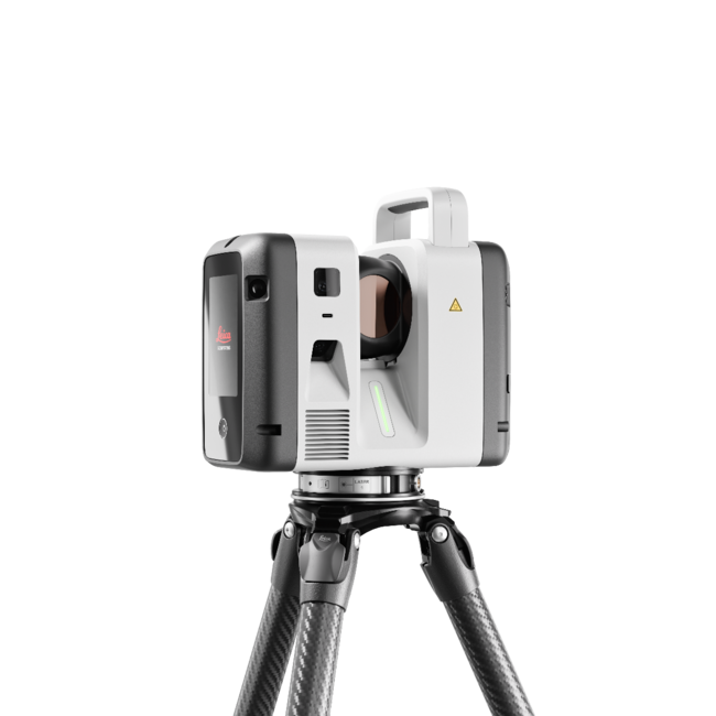
Leica RTC700 3D Laser Scanner
The Leica RTC700 is the flagship of the RTC series — the model to reach for when range, accuracy, and capture speed all have to be at their maximum. It scans up to two million points per second to a class-leading 270 meters, and adds a dedicated Area Scan mode that resolves detail down to 0.8 mm at 10 meters, the finest in the lineup. For teams documenting industrial plants, large-scale infrastructure, and complex survey environments, the RTC700 captures high-density 3D data with confidence in the toughest conditions.
Industry-Leading 270 m Range
The RTC700 reaches a maximum range of 270 meters, capturing to 3.5% albedo at 85 m, 8% at 130 m, and 32% at the full 270 m. That reach lets a single setup cover expansive plants, structures, and infrastructure corridors that would otherwise demand multiple positions with a shorter-range scanner — fewer moves, fewer registrations, faster completion.
Highest Detail with Dedicated Area Scan
Beyond the standard 1.6, 3, 6, 12, and 25 mm resolution steps, the RTC700 offers an Area Scan mode that captures fine detail down to 0.8 mm at 10 meters, exclusive to the RTC700 in the series. For tight tolerances on industrial components, intricate as-builts, and high-value assets, it delivers the density demanding projects require — while still capturing up to 2,000,000 points per second.
A Full On-Board Surveying Suite
Through Leica Cyclone FIELD 360, the RTC700 supports complete surveying workflows: setup over a known point, known backsight, resection, traverse, target measurements to 75 meters, targets from a full-dome scan, and Area Scan. That turns the scanner into a true survey instrument, letting crews tie reality-capture data directly into project control without carrying a separate total station.
Built for Coordinated, Multi-Scanner Operations
Livelink connectivity in Cyclone FIELD 360 and Hexagon GeoCloud synchronizes field crews, multiple scanners, and office teams in real time. As data is captured, project information becomes visible across connected environments, so large teams coordinate activity and make decisions faster. Finalize and deliver in Cyclone REGISTER 360 PLUS with full reporting on errors, overlap, and tolerances.
Quick Facts
Up to 2,000,000 points per second
Industry-leading range up to 270 m
Area Scan detail down to 0.8 mm at 10 m (exclusive to RTC700)
Full-dome scan + HDR image in ~1 min 40 s
Complete on-board surveying suite (traverse, resection, known backsight & more)
72 MP / 432 MPx HDR imaging, VIS auto-registration, Livelink collaboration
Laser Class 1 (eye-safe), IP55 rated, self-calibrating
Ideal for industrial plants, large-scale infrastructure, and complex surveying
RTC700 Performance Highlights
Shared RTC Platform Specifications
How the RTC700 Compares
All three RTC scanners share one platform and identical baseline data quality. What separates them is reach, speed, resolution, and survey capability. The RTC700 sits at the top on every axis.
Not sure the flagship is the right fit? Compare the RTC500 and RTC300, or ask our experts to spec the line to your projects.
Frequently Asked Questions
-
The Leica RTC700 is the flagship terrestrial 3D laser scanner in Leica's RTC series. It captures up to two million points per second to a maximum range of 270 meters, offers a dedicated Area Scan mode down to 0.8 mm at 10 meters, and includes a full on-board surveying suite — making it the highest-performing scanner in the lineup.
-
The RTC700 reaches 270 meters, the longest in the RTC series, capturing to 3.5% albedo at 85 m, 8% at 130 m, and 32% at 270 m, with a minimum range of 0.5 meters.
-
All three share the same imaging and connected-workflow platform. The RTC700 stands apart with the longest range (270 m vs. 130 m and 85 m), an exclusive Area Scan mode resolving to 0.8 mm at 10 m, a finer 1.6 mm resolution step, and a complete on-board surveying suite including traverse and known backsight.
-
The RTC700 supports survey workflows such as setup over a known point, known backsight, resection, traverse, and target measurements to 75 meters directly through Cyclone FIELD 360, letting many teams tie scan data into project control without a separate instrument. Whether it fully replaces a total station depends on your project's requirements — our experts can advise.
-
Area Scan is a high-density capture mode, exclusive to the RTC700 in the series, that resolves detail down to 0.8 mm at 10 meters — ideal for tight-tolerance industrial components and intricate as-built documentation.
Ready to Put the RTC Series to Work?
Our reality-capture specialists help you match the right RTC scanner to your projects, budget, and workflow — then back it with certified training, software integration, and full implementation support. Buy, rent, or schedule an on-site demo.